
Google has launched Google Earth AI, a collection of geospatial AI models and data sets designed to help businesses, governments, and scientists support decision-making in a world being altered by climate change.
The offering expands upon Google’s Geospatial Reasoning program, a research effort announced in April that uses generative AI to accelerate geospatial problem-solving. The program feeds the world's geospatial information into AI models to capture the complex interplay between population behaviors and their local environment.
The models will be available through a trusted tester program, with inaugural participants including WPP, Airbus, Maxar, and Planet Labs.
Examples of its use include detailed weather predictions, flood forecasting, and wildfire detection. In addition, the models help support better urban planning and public health decisions by providing a deep analysis of imagery, population dynamics, and urban mobility.
Commenting on the launch, Juliet Rothenberg, product director of Earth & Resilience AI at Google, said on LinkedIn: "Our Earth AI models are already powering products used by millions, such as flood and wildfire alerts in Search and Maps, and climate insights via Google Maps Platform."
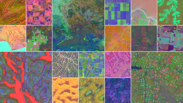
In addition, Google DeepMind also announced AlphaEarth Foundations. According to the company, the AI model functions like a virtual satellite, accurately and efficiently characterizing the planet’s entire terrestrial land and coastal waters by integrating huge amounts of Earth observation data into a unified digital representation.
The program works by combining large volumes of data from public sources, including satellite images, radar, 3D laser mapping, and climate simulations. It subsequently combines the information to analyse the world's land and coastal waters in sharp, 10x10 meter squares, allowing it to track changes over time with “remarkable precision.”
According to the press release, the system's key innovation is in its ability to create a highly compact summary for each square, which requires 16 times less storage space compared to other AI systems tested, reducing the cost significantly.
The unified digital representation provides scientists with a more complete and consistent picture of our planet's evolution, which DeepMind says allows them to make more informed decisions on critical issues like food security, deforestation, urban expansion, and water resources. In addition, it allows researchers to create detailed, consistent maps on demand, allowing for real-time insights into crucial issues.
Google said that to ensure its viability for real-world use, the model was rigorously tested and excelled at a wide range of tasks over different periods, including identifying land use and estimating surface properties.
“AlphaEarth Foundations brings the benefits of foundation models to satellite data, building a 'virtual AI satellite' – producing embeddings that can be easily used by other AI models for diverse applications. More than 50 partners have used this over the past year – the UN FAO, Stanford, MapBiomas, and more – and they’ve found AlphaEarth requires significantly less human input and produces a 24 percent lower error rate than similar models,” said Rothenberg.





Comments